In meteorology, convection refers to vertical movements of air driven by temperature differences, which play a crucial role in shaping the weather, cloud formation and wind dynamics. While large-scale atmospheric convection shapes global weather patterns, small-scale convection exerts a direct and immediate influence on sailing conditions, affecting the safety and strategy of navigation. By understanding the principles of convective processes and the associated weather phenomena, sailors can enhance sailing efficiency and safety during their voyages.
Convection begins when the sun warms the Earthʼs surface unevenly, which results in the formation of pockets of warm and moist, buoyant air. The air that is warmer than its surroundings is considered unstable and starts rising, while cooler, denser air sinks to replace it, thus initiating convective cells.
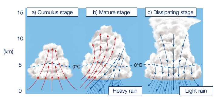
1. Structure of a convective cloud in three stages of its life cycle: a) Developing cumulus stage, b) Mature stage, and c) Dissipating Stage.
The ascending air parcels cool adiabatically, eventually reaching a level where condensation occurs, forming fair-weather cumulus clouds Fig. 1a). In this stage, updrafts (upward motion of air) cause the cloud to grow vertically. Eventually the cloud evolves into a mature storm cell Fig. 1b), which happens when water droplets trapped in the cloud become too heavy and fall through the cloud dragging the surrounding air downward. The updraft continues in a portion of the storm and carry the cloud high into the atmosphere, where upper-level winds draw the cloud downwind to create a characteristic anvil cloud. The downdrafts are accompanied by intense precipitation and strong gusts. If the rain falls in the same place where the air is rapidly rising, the cloud can “rain itself out,ˮ meaning that it will weaken quickly as the updraft cannot sustain itself. Factors such as cooling temperatures, or the intrusion of drier air can contribute to the dissipation of cumulus clouds Fig 1c). However, in favourable conditions, such as sufficient instability, moisture supply, and wind shear, the clouds can evolve into potentially dangerous thunderstorms and squalls.
Monitoring weather forecasts and satellite imagery helps sailors anticipate convection-driven weather phenomena, allowing for proactive navigation adjustments. However, most weather models cannot accurately predict small-scale convective events, the associated wind patterns and hazardous weather conditions.
While convection can offer favourable wind conditions, it also poses risks, that sailors must anticipate. There are a few forecasting tools that might help to indicate convective weather and its severity. The most commonly used indicator of forming convective clouds and storms is the Convective Available Potential Energy index CAPE. It is used in meteorology to quantify the amount of atmospheric instability and can signal the potential for hazardous weather. Severe thunderstorms require high CAPE values and the higher the CAPE value, the more energy available to promote thunderstorm growth. Typically, CAPE values well over 1000 J/kg indicate that there is potential for moderate to severe thunderstorms. The downside of CAPE is that its threshold value necessary for severe storms to occur varies depending on the environment. In higher latitudes the value of 1500 J/kg is enough for severe storm to develop, while in the tropics this value should reach over 3000 J/kg.
While sufficiently high CAPE is necessary for the formation of intense convection, other environmental conditions have to be favourable too. Another important factor is the moisture supply, which is the fuel for convection and needs to be high enough so that clouds can form in the first place. On days with very high CAPE and dry air, storms are very unlikely. But if there is enough moisture supply and a storm does develop, there is a good chance that it will be severe.
For sailors, cumulus clouds serve as visual cues of localized convection and potential changes in wind patterns. Clouds set pace for short-term strategy, so it is important to understand how they affect the observed wind. First and foremost, we need to distinguish between the different phases of cloud formation Fig. 2. The cumulus clouds are still in their convective stage and are associated with updrafts. Dark gray cumulonimbus clouds generate rain and indicate downdrafts leading to the expulsion of rain from their base.
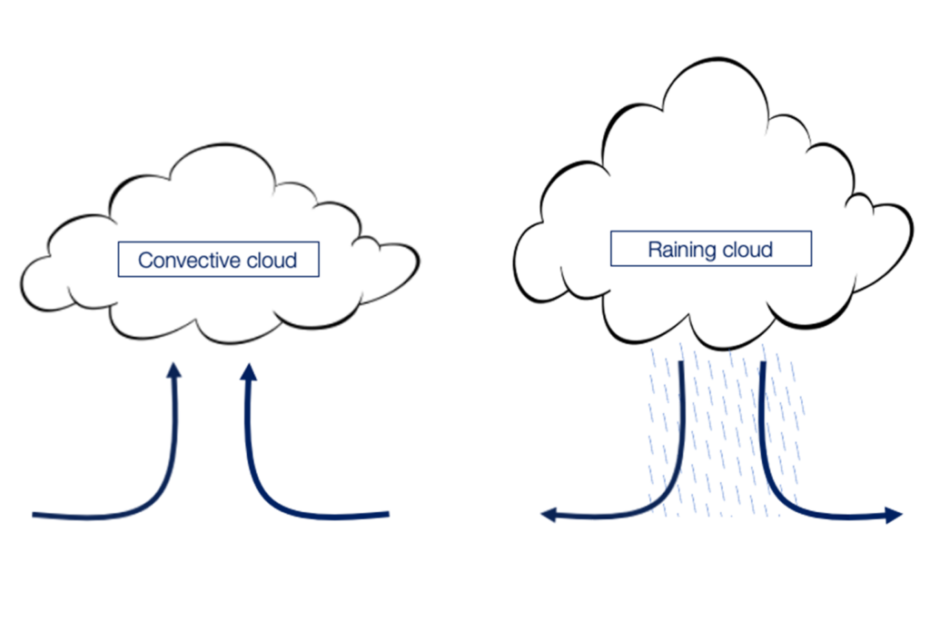
Fig. 2. Vertical motions of air in a convective (left) and raining cloud (right)
Convective clouds are a clear indicators of thermal updrafts, which create localized low pressure systems and windless zones (lulls) right underneath the clouds Fig. 3. Contrarily, more wind is generated at the edges of the clouds where the cold air sinks. In this situation the best practice is to sail in between clouds and take advantage of the appearing gusts. In the Northern Hemisphere, clouds usually move downwind and to the right of the prevailing surface wind, which is important to remember if we want to avoid getting stuck in the lulls.
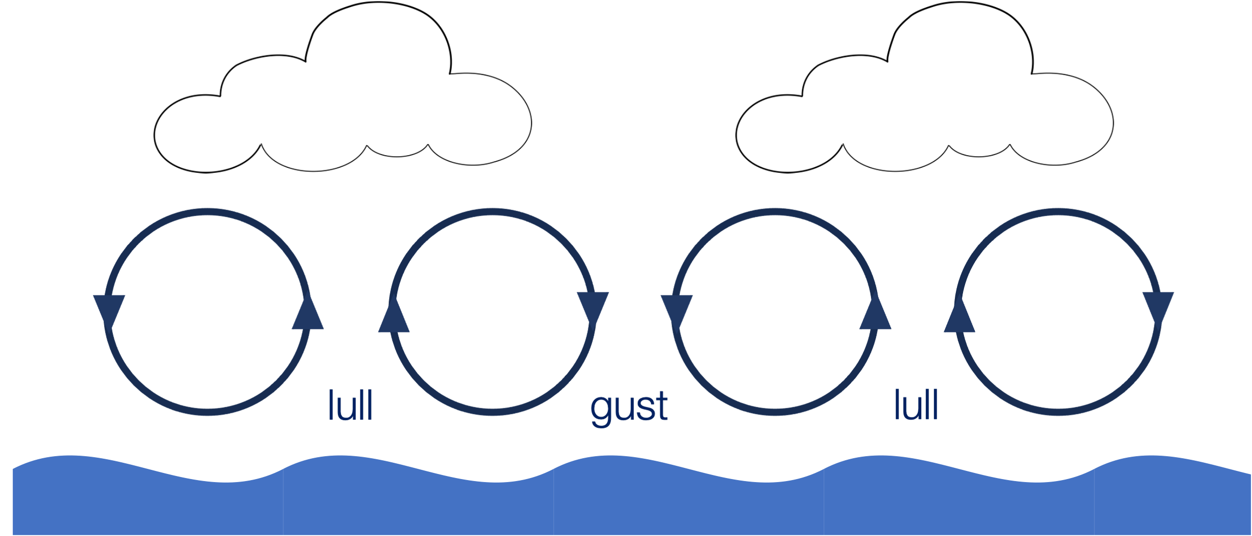
Fig 3. Lulls and gusts pattern associated with convective cumulus clouds.
Downdrafts associated with raining clouds, generate outward winds once they reach the sea surface Fig. 4. The lower the cloud base, the less space there is for the air to move to the sides, therefore generating stronger winds. These winds interact with the large-scale wind, either by enhancing them or stalling them completely. It is an important factor when sailing in the easterly tradewinds, where the best strategy is to stay ahead of the cloud. In this region, the expelled air couples with the prevailing wind, which creates some fair winds. On the other hand, if the cloud gets past you, you will end up in a windless zone as the downpour vanishes the prevailing wind. In general, you should pay attention to the way the cloud is moving, as more wind can be found on the forward motion side.
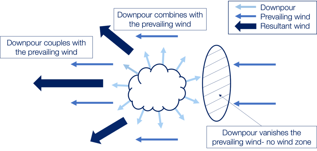
Fig. 4. Wind pattern (top view) under a raining cumulonimbus cloud.
Mastering the the convective weather requires a combination of observational skills, meteorological knowledge, and practical experience. By gaining better understanding of the environmental forces that drive convection, and the resulting wind patterns sailors can make informed decisions to optimize their routes, enhance sailing efficiency and ensure the safety of their vessel and crew. Marine Weather Intelligence prioritizes the incorporation of weather models and satellite data into development of tools used to improve the accuracy of our weather routing services, as safety of navigation is our main objective.