Convection drives some of the most demanding weather at sea, squalls, thunderstorms, and rapidly shifting winds. Understanding how convective clouds form, organise, and dissipate gives every maritime operation, from racing yachts to offshore installations, a decisive advantage in strategy and safety.
Why convection matters at sea
Few weather phenomena change conditions as fast, or as locally, as convection. A patch of open water can go from a gentle breeze to 40-knot gusts and torrential rain in minutes, then return to calm just as quickly, all within a few nautical miles of clear sky. That volatility makes convective weather one of the hardest categories of risk to plan around, and one of the most consequential to get wrong.
The stakes differ by operation, but the underlying hazard is the same:
- Racing and cruising yachts face sudden wind shifts and squalls that can overpower a sail plan or a crew in seconds.
- Shipping operators need reliable windows for port approach, cargo operations, and coastal transits where a squall line can force a costly delay.
- Offshore energy projects depend on stable conditions for lifting, transfer, and personnel movements, operations with little tolerance for an unforecast gust front.
- Towage and heavy transport convoys, often slow-moving and route-constrained, have the least ability to manoeuvre away from a developing storm.
Understanding how convective clouds develop, organise, and dissipate is the first step to managing that risk. This article walks through the physics, the storm types you’re likely to encounter, why standard weather models struggle with them, and what that means in practice across Marine Weather Intelligence’s operations.
The physics of convection: (S)LIM
Convection begins when the sun warms the Earth’s surface unevenly, forming pockets of warm, buoyant air. Air that is warmer than its surroundings starts rising while cooler, denser air sinks to replace it, initiating a convective cell. It’s the same principle as water boiling in a pot, applied to the atmosphere.
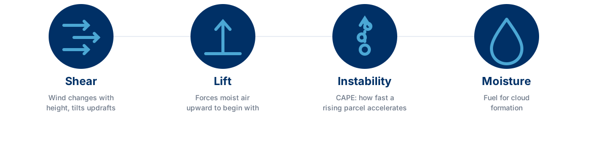
But warm air alone doesn’t guarantee a thunderstorm. Forecasters look for four ingredients, often remembered by the acronym (S)LIM:
- Shear a change in wind speed or direction with height, which tilts and organises updrafts, turning a short-lived shower into a longer-lived, more severe storm.
- Lift a mechanism that forces moist air upward in the first place: solar heating, converging winds, a mountain range, or the leading edge of a front.
- Instability the atmosphere’s willingness to let a rising air parcel keep rising, quantified by CAPE (Convective Available Potential Energy). The higher the CAPE, the faster air can rise and the stronger the resulting updrafts and storms.
- Moisture the fuel for cloud formation. Without enough low-level moisture, rising air simply can’t condense into a storm cloud.
CAPE is the most widely used single indicator of storm potential, but the threshold for concern varies by region and latitude, as shown above. It’s also necessary but not sufficient on its own: moisture supply, lift, and shear all have to align for a storm to actually develop.
Life cycle and anatomy of a convective storm
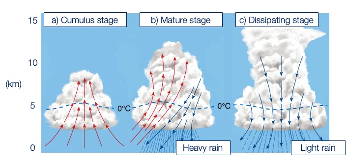
A convective storm evolves through three recognisable stages:
- Cumulus stage an updraft builds the cloud vertically. No rain has yet reached the ground.
- Mature stage the storm’s most intense phase. Rain falls, and the resulting downdraft spreads outward at the surface, feeding new lift ahead of the storm.
- Dissipating stage downdrafts dominate throughout the cell, cutting off the storm’s own power source.
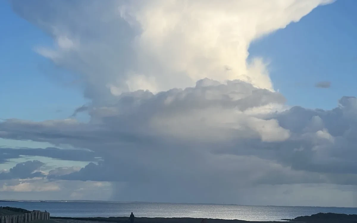
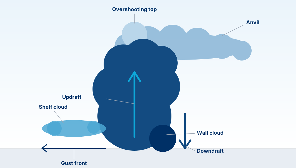
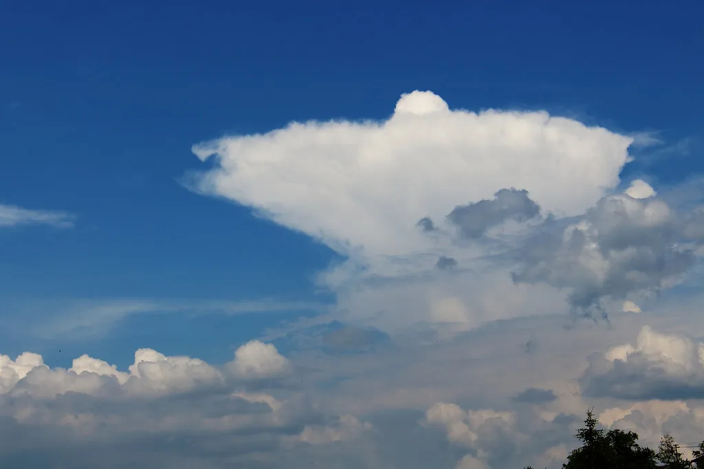
A mature storm develops a distinctive anatomy that’s worth being able to read at a glance: the anvil spreading downwind at the top, an overshooting top where a strong updraft punches above it, a gust front racing out ahead at the surface (sometimes visible as a low, rolling shelf cloud), and, in the most organised storms, a wall cloud marking the strongest inflow. Recognising these features from the deck or bridge, well before radar or satellite confirms them, buys valuable extra minutes to react.
From single cells to supercells: know your storm
Not all convective storms carry the same risk, and the type in front of you changes the right operational response.
- Single-cell storms (“popcorn” convection), small, brief, and driven by daytime heating. They last 20–30 minutes and form where wind shear is weak. Usually a minor, localised nuisance.
- Multicell storms the most common type. New cells continually regenerate along the storm’s own gust front, so the system as a whole can persist for hours even though individual cells last only 30–60 minutes. Can produce hail, strong gusts, and brief tornadoes.
- Supercells long-lived (over an hour), highly organised storms built around a rotating updraft. Rare, but responsible for a disproportionate share of severe weather: large hail, damaging straight-line winds, and most strong tornadoes.
- Mesoscale Convective Systems (MCS) and squall lines clusters or lines of storms acting as one system, sometimes spanning hundreds of miles and lasting over 12 hours. Squall lines in particular move fast and pass quickly, but their leading edge can bring an abrupt, sustained wind event across an entire route or worksite rather than a single, avoidable cell.
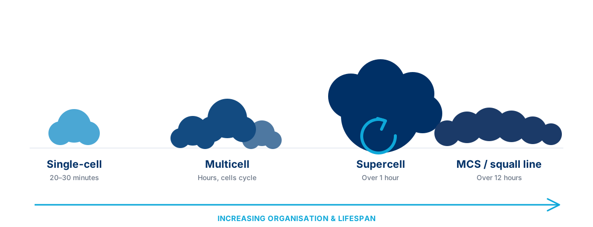
For an offshore installation or a towage convoy, an MCS or squall line is often the more operationally significant threat: it isn’t something you can simply sail around, it can close an entire corridor for hours.
Where weather models fall short, and what Marine Weather Intelligence adds
Standard numerical weather models struggle with convection for a structural reason: the processes involved (individual updrafts, local convergence lines, cell-scale triggering) happen at spatial and temporal scales finer than most global and even regional models resolve. A model can tell you the atmosphere is primed for storms; it’s much less reliable at telling you exactly where and when a specific cell will fire, especially more than a few hours out.
This is precisely the gap Marine Weather Intelligence’s forecasting is built to close: blending high-resolution model output with satellite and radar-based nowcasting to track existing convection and extrapolate its short-term evolution, rather than relying on the model’s guess of where storms might form. It’s also the thinking behind Marine Weather Intelligence’s HWZSea early-warning research (with the European Space Agency), which specifically targets short-notice hazards like thunderstorm nowcasting and weather-front detection that traditional forecasting handles poorly.
Convection across Marine Weather Intelligence’s operations
MWI Yachts
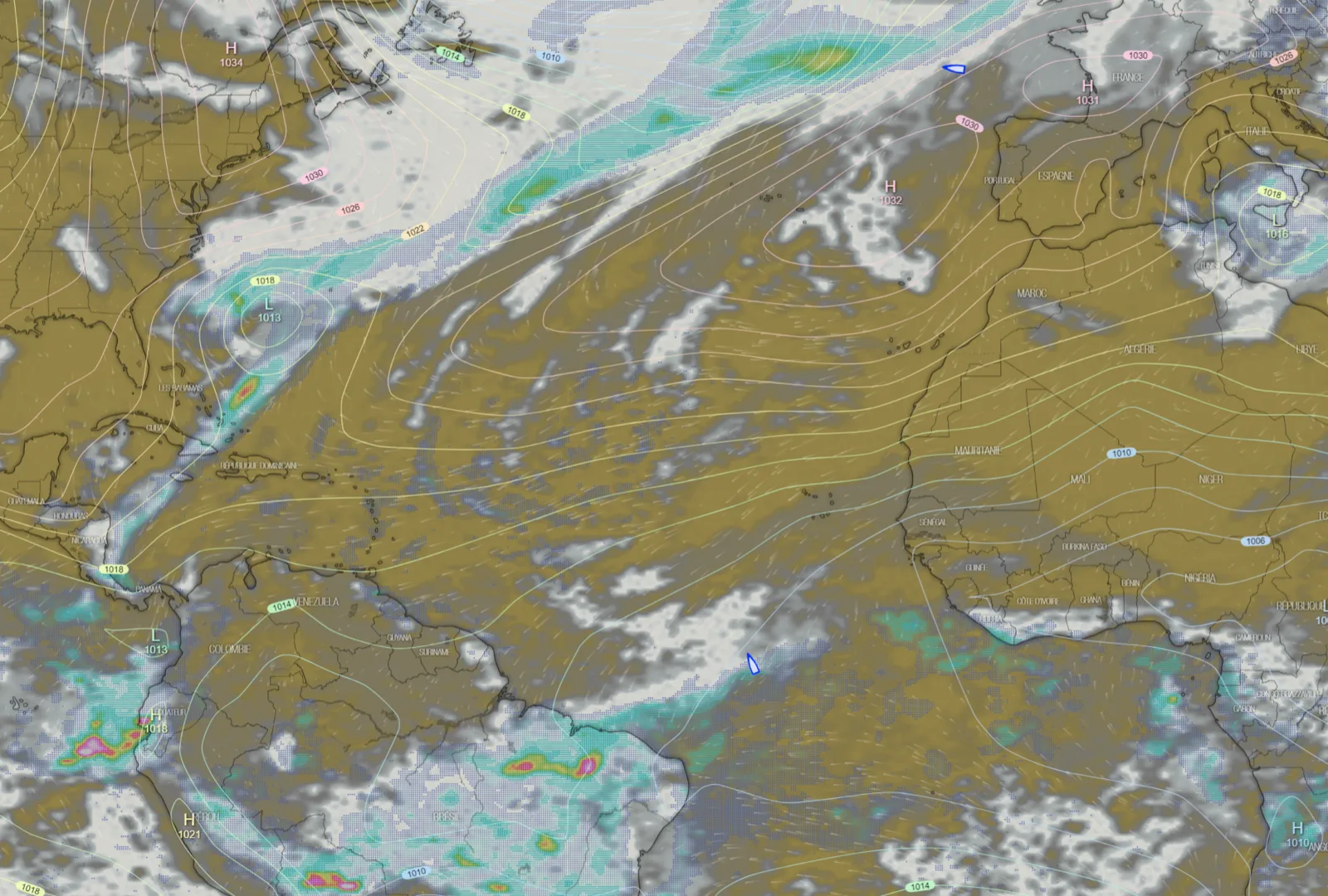
For sailors, cumulus clouds are a visual cue you can act on in real time. Growing cumulus clouds sit above localised updrafts and low pressure, creating windless lulls directly underneath, while more wind is generated at their edges, where cooling air sinks. Once a cumulonimbus starts raining, the downdraft reaches the surface and expels air outward; the lower the cloud base, the stronger that outflow. In the Northern Hemisphere, clouds typically track downwind and to the right of the prevailing surface wind, so staying between clouds and steering into the gusts as they appear is generally the winning strategy, especially in the trade winds, where getting caught behind a cloud can mean losing significant ground.
MWI Shipping
A squall line arriving during a port approach, pilotage, or cargo transfer can force operations to pause with little warning. Early identification of the gust front and its expected timing lets masters and operators sequence port calls and cargo windows around the hazard instead of reacting to it.
MWI Offshore Energies
Lifting, personnel transfer, and other offshore operations depend on stable wind and visibility. A single unforecast gust front can force an abrupt stop mid-operation. Tracking convective development in the hours ahead, rather than relying on a single model run, supports safer go/no-go decisions for weather-sensitive lifts.
MWI Towage & Heavy Transport
Slow-moving convoys and constrained routes have the least room to divert around a developing storm. For these operations, the priority is longer lead time: distinguishing an isolated single-cell nuisance from an organised, longer-lived MCS or squall line that could close a corridor for hours.
Conclusion
Mastering convective weather takes a combination of observational skill, meteorological understanding, and the right data at the right time. Knowing how convection forms, how a storm’s life cycle and structure signal its severity, and why standard models under-forecast these events is what turns a hazard into a manageable operational variable, whatever the mission at sea.
Marine Weather Intelligence builds this understanding directly into its forecasting and routing services, combining high-resolution weather models with satellite and radar-based nowcasting to give every one of its business lines, from racing yachts to offshore installations, an earlier, sharper view of convective risk.