Introduction
Approximately 90% of trade occurs through maritime shipping, which makes it a significant contributor to greenhouse gas emissions, accounting for 3% of global emissions [1]. Reducing carbon footprint of shipping industry is therefore crucial to combat climate change and achieve the UN’s Sustainable Development Goals. One effective approach to decarbonize the industry is through weather routing. It is a cost-effective tool, which allows shipping companies to select the most energy-efficient navigation routes.
Fuel consumption in shipping
In the past, the economic focus of shipping was to minimize the total distance travelled between ports. However, the maritime industry has evolved, recognizing the importance of energy efficiency objectives such as minimizing fuel consumption and greenhouse gas emissions. With fuel costs representing a significant portion of total operating expenses (50-60%) [1], reducing fuel usage not only supports sustainability, but also brings financial benefits.
The role of weather routing
Fuel consumption can be reduced by avoiding routes that require navigation through bad weather and taking advantage of favourable conditions instead. In particular, adverse weather conditions, such as rough sea state, strong winds and currents can increase voyage time and ship’s resistance, leading to higher fuel consumption rates. The optimal routes can be determined through weather routing, which incorporates weather forecasts into voyage planning. According to the International Maritime Organization (IMO), weather routing can reduce fuel consumption by at least 3%, which is substantial, given the scale of the shipping industry [1]. Other benefits of weather routing include enhanced safety of maritime operations, and reduced delays by avoiding unfavourable conditions.
Ocean Currents
Understanding the speed and direction of ocean currents allows for their utilisation by choosing routes that minimize the resistance caused by currents, resulting in shorter voyage durations and consequently, reduced fuel usage. Strong ocean currents that can potentially be leveraged, usually flow near the western boundaries of ocean basins. Their location is rather stable and often coincides with major shipping routes [2].
Now, the question is how significant these currents are for energy efficiency of ships. To answer this question, we looked into the impact of the Kuroshio current on transit time with the use of weather routing tools.
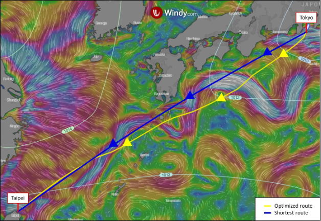
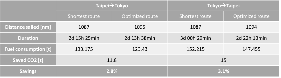
Kuroshio Current- small changes, big impact
The shortest distance of 1087 nm between these two ports can be travelled in 63.4 hours at the speed of 15 kts on the route along the current. The optimized route that utilizes the current is 8 mn longer, but takes 1.8 hours (or 2.8%) less to complete. The return trip of the straight route opposes KC and therefore takes 72.5 hours. The alternative route that avoids the adverse current now takes 70.2 hours, which makes it 3.2% faster while being 7 mn longer.
The equivalent fuel savings of 3% refer only to shorter travel duration, but there are more aspects to take into account. For instance, ships sailing against the current would consume more fuel to overcome stronger resistance and maintain the desired speed. Moreover, faster voyage means less time-dependent operating costs. The resulting fuel and financial savings are therefore significant. The efficiency gains from ocean currents are even more pronounced for slower vessels, because currents account for a larger percentage of the vessel’s speed. For instance, a ship travelling at 10 kts can save 7.3% in transit time by avoiding adverse KC.
What about CO2 emissions?
Conclusion
It is worth noting that while weather routing softwares have made crucial progress in optimizing routes based on weather data, they still face challenges in effectively incorporating ocean current data. These limitations will be explored in our future studies.
References
[1] IAMU, Istanbul Technical University, Improving Energy Efficiency of Ships Through Optimisation of Ship Operations, 2015
[2] Chang et al., The Journal of Navigation, Global Energy-saving map of Strong Ocean Currents, 2015